Official Discussion issued by the National Hurricane Center
Martin (AL162022) DATA RELEASED: 11/3/2022 3:00:00 PM UTC
|
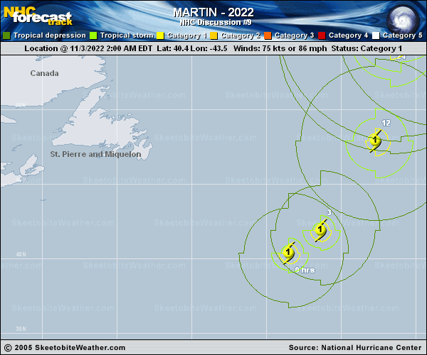
Copy of official data Hurricane Martin Discussion Number 9 NWS National Hurricane Center Miami FL AL162022 300 PM GMT Thu Nov 03 2022 Martin is nearing the completion of its extratropical transition, which will likely conclude in the next few hours. Although the cyclone has maintained some inner-core convection, satellite imagery indicates that its center is beginning to get stretched out as it becomes a frontal cyclone. There is also no longer any indication of an eye-like feature in recent microwave or infrared imagery. Martin's hybrid structure adds uncertainty to the intensity estimate, since techniques like Dvorak weren't designed for cyclones that are becoming frontal. Therefore, even though most of the satellite-based intensity estimates have decreased over the past 6 hours, the estimated maximum winds are held at 75 kt since baroclinic processes are believed to be supporting the maintenance of intensity of the cyclone at this time. Martin is moving at a remarkably fast forward speed, with an initial motion of 035/42 kt. Once it is post-tropical, Martin is forecast to take a northward turn and begin slowing down as it interacts with another non-tropical system to its northwest. Martin is expected to become a very large and powerful extratropical cyclone during this time, with most global models forecasting a minimum pressure between the high 920s and mid 930s (mb). After a day of relatively slow movement, an occluded and slowly weakening post-tropical Martin should begin to move eastward on Saturday. By Sunday or Sunday night, the cyclone is forecast to have weakened enough to open into a trough embedded within a broad low over the far north Atlantic. The track and intensity forecasts are heavily based on a blend of the GFS and ECMWF global models, but it's worth noting that other models like the HWRF and UKMET support the same general evolution of Martin through the weekend. FORECAST POSITIONS AND MAX WINDS INIT 03/1500Z 45.6N 37.9W 75 KT 85 MPH 12H 04/0000Z 51.4N 34.9W 75 KT 85 MPH...POST-TROP/EXTRATROP 24H 04/1200Z 56.0N 36.0W 65 KT 75 MPH...POST-TROP/EXTRATROP 36H 05/0000Z 56.0N 34.0W 60 KT 70 MPH...POST-TROP/EXTRATROP 48H 05/1200Z 54.5N 28.5W 50 KT 60 MPH...POST-TROP/EXTRATROP 60H 06/0000Z 54.0N 20.9W 45 KT 50 MPH...POST-TROP/EXTRATROP 72H 06/1200Z 55.0N 14.0W 40 KT 45 MPH...POST-TROP/EXTRATROP 96H 07/1200Z...DISSIPATED $$ Forecaster D. Zelinsky |