Official Discussion issued by the National Hurricane Center
Lisa (AL152022) DATA RELEASED: 11/4/2022 10:00:00 PM UTC
|
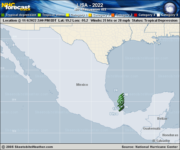
Copy of official data Tropical Depression Lisa Discussion Number 22 NWS National Hurricane Center Miami FL AL152022 1000 PM CDT Fri Nov 04 2022 Lisa continues to barely hang on to tropical cyclone status this evening. The broadening low-level circulation has a single burst of deep convection displaced well to the northeast of the center by strong south-southwesterly vertical wind shear. The subjective satellite intensity estimates support an initial intensity of 25 kt. Environmental conditions are not expected to improve in the next couple of days. The global models forecast the mid-level environment to become drier and the vertical wind shear to strengthen further. Simulated satellite imagery shows the little remaining convection should collapse in less than 12 hours. Therefore, the official intensity forecast now predicts Lisa will become a post-tropical cyclone by Saturday morning. The depression appears to be moving slowly to the north at 3 kt. This decrease in forward motion seems to indicate that Lisa will not make as much northward progress before the low-level circulation stalls and drifts southward in about 12 hours or so. The new track forecast now shows a turn to the south occurring sooner, similar to the corrected consensus aid guidance. FORECAST POSITIONS AND MAX WINDS INIT 05/0300Z 19.5N 95.5W 25 KT 30 MPH 12H 05/1200Z 20.0N 95.5W 25 KT 30 MPH...POST-TROP/REMNT LOW 24H 06/0000Z 20.1N 95.3W 25 KT 30 MPH...POST-TROP/REMNT LOW 36H 06/1200Z 19.9N 95.2W 20 KT 25 MPH...POST-TROP/REMNT LOW 48H 07/0000Z 19.6N 95.2W 20 KT 25 MPH...POST-TROP/REMNT LOW 60H 07/1200Z...DISSIPATED $$ Forecaster Bucci |