Official Discussion issued by the National Hurricane Center
Lisa (AL152022) DATA RELEASED: 11/3/2022 10:00:00 AM UTC
|
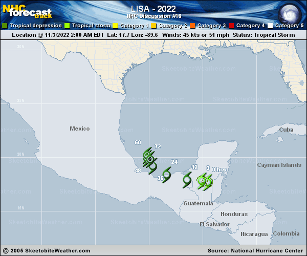
Copy of official data Tropical Depression Lisa Discussion Number 16 NWS National Hurricane Center Miami FL AL152022 1000 AM CDT Thu Nov 03 2022 Lisa has been inland for about 18 hours, and there are no observations of tropical-storm-force winds. Also, using a standard rate of decay over land shows the cyclone weakening below tropical storm intensity by now. Therefore the system is being downgraded to a tropical depression on this advisory. Satellite fixes and observations from the Sabancuy, Mexico, radar indicate that the cyclone continues moving mainly westward and the initial motion estimate is 280/9 kt. Over the next couple of days, Lisa should gradually turn to the northwest and north while moving along the southwestern periphery of a mid-level high. In 2-3 days, the increasingly shallow cyclone is expected to meander over the southwestern Gulf of Mexico within a weak low-level flow. The official track forecast is similar to the previous one and follows the multi-model consensus guidance, TVCA. Lisa is forecast to move over the waters of the Bay of Campeche in 24 hours. Global models show strong southerly to south-southwesterly upper-level winds across most of the Gulf of Mexico during the next few days. The associated strong vertical shear should prevent re-intensification. Global model simulations also show Lisa's mid- to upper-level vorticity maximum being sheared north-northeastward into the northern Gulf while the low-level circulation remains over the Bay of Campeche. The official intensity forecast, like the previous ones, shows the system degenerating into a remnant low in 3 days. Key Messages: 1. Localized flash flooding is expected across portions of southeast Mexico. FORECAST POSITIONS AND MAX WINDS INIT 03/1500Z 18.0N 91.0W 30 KT 35 MPH...INLAND 12H 04/0000Z 18.2N 92.4W 25 KT 30 MPH...INLAND 24H 04/1200Z 18.9N 94.2W 25 KT 30 MPH...OVER WATER 36H 05/0000Z 19.8N 95.1W 25 KT 30 MPH 48H 05/1200Z 20.5N 95.3W 25 KT 30 MPH 60H 06/0000Z 20.2N 95.0W 25 KT 30 MPH 72H 06/1200Z 19.8N 94.9W 20 KT 25 MPH...POST-TROP/REMNT LOW 96H 07/1200Z...DISSIPATED $$ Forecaster Pasch |